Earthquakes
The Natural State has felt its fair share of earthquakes. In 1811-1812 a series of powerful earthquakes measuring over magnitude 7.5 rattled the residents of northeast Arkansas. Cabins collapsed, people were frightened, and the land surface was severely changed by liquefaction. These earthquakes happened in the New Madrid seismic zone (NMSZ), an active fault system that extends from Cairo, Illinois to Marked Tree, Arkansas. The earthquake zone has been active for hundreds of years. What if another series of major earthquakes were to strike this region again? Would your business or family be prepared?
The Arkansas Geological Survey generates seismicity maps based on data provided by the Center for Earthquake Research and Information (CERI) at the University of Memphis, the Department of Earth and Atmospheric Sciences at Saint Louis University, the United States Geological Survey, and the Arkansas Center for Earthquake Education and Technology Transfer at the University of Arkansas in Little Rock.
Recent Earthquake Activity Near Bull Shoals Lake, AR ![]() (9.87 MB)
(9.87 MB)
Arkansas Seismicity Map ![]() (6.08 MB). This map illustrates the location and magnitude
of reported earthquakes that have occurred in Arkansas from 1699 to 2023.
(6.08 MB). This map illustrates the location and magnitude
of reported earthquakes that have occurred in Arkansas from 1699 to 2023.
Earthquake feature recognition workshop/field trip II
Earthquake Awareness month, new USGS earthquake hazard map, NEHRP updates, and more…
Center for Earthquake Research and Information (CERI) recent earthquake map of central and eastern U.S.
View details »Up-to-date USGS Map for all earthquakes in AR for the past 7 days
View details »Search the USGS Earthquake Catalog
View details »Arkansas Earthquake Archive 1699 - 2024
This earthquake archive list was made from a selection of seismic events that have occurred from 1699 to present in Arkansas. The seismic data have been cited from publications of the Center for Earthquake Research and Information (CERI) at the University of Memphis, the Department of Earth and Atmospheric Sciences at Saint Louis University, the United States Geological Survey (USGS), the Eastern Section of the Seismological Society of America and the University of Arkansas at Little Rock. We extend our appreciation to John David McFarland (Arkansas Geological Survey) for compiling the original earthquake database.
Earthquakes In Arkansas
Numerous earthquakes occur every year throughout the State of Arkansas, but most go unnoticed. Earthquakes that are felt can be startling, and serve as good reminders that Arkansas is located near one of the most hazardous earthquake zones in the country. Earthquakes have been historically documented in Arkansas, as far back as 1699, by missionaries traveling down the Mississippi River near Helena (Phillips County), Arkansas. Although, it is uncommon for major earthquakes to occur far away from active tectonic boundaries, earthquakes associated with the New Madrid seismic zone (NMSZ), an active earthquake zone extending from Cairo, Illinois, into Marked Tree (Poinsett County), Arkansas, have been some of the largest earthquakes to ever strike North America.
What Causes An Earthquake?
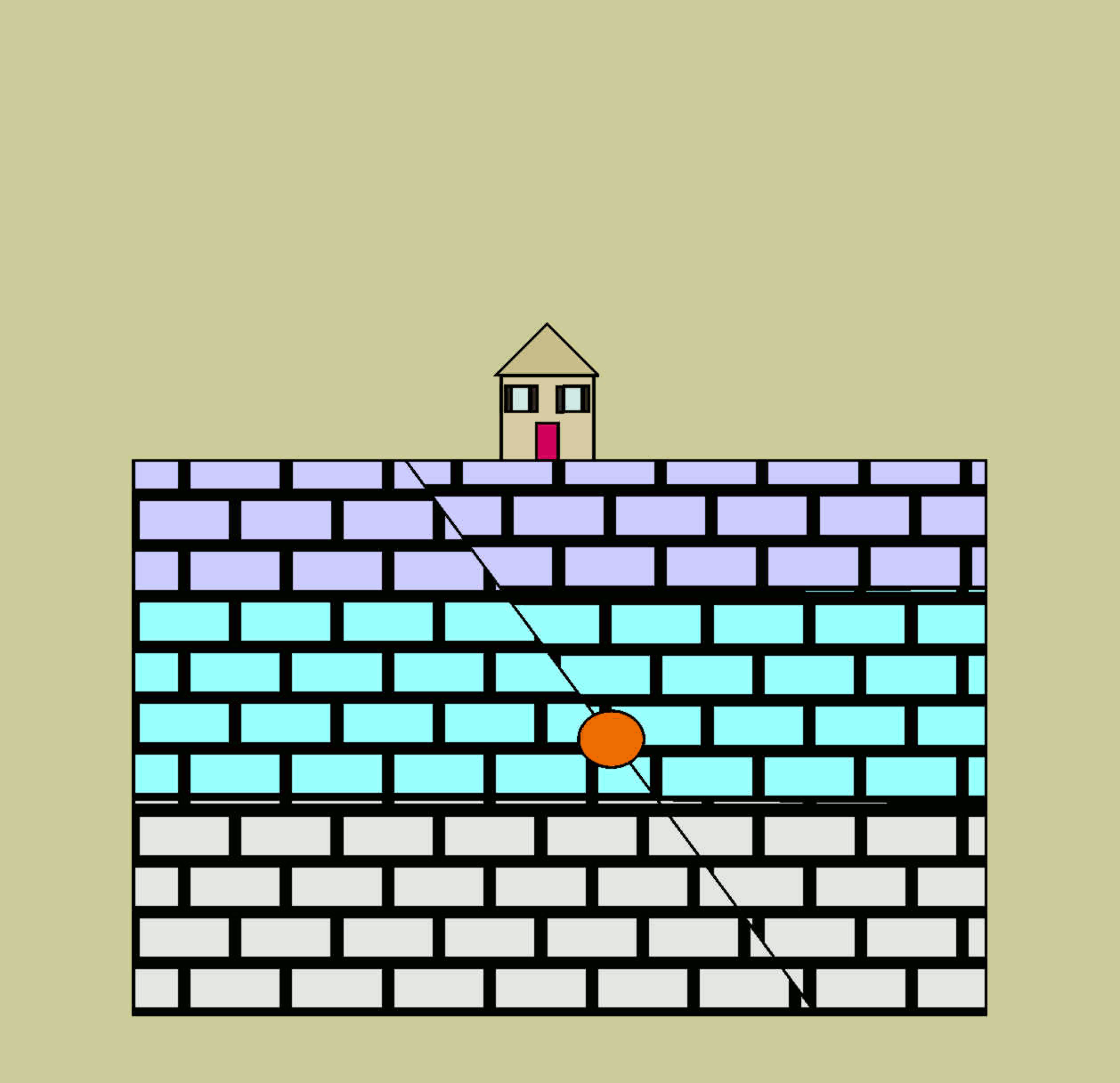
Earthquakes are caused by movement along geologic faults, or fractures in the Earth's crust. When a fault moves, energy is released and transfers through the earth causing the shaking that is experienced during an earthquake. Arkansas has hundreds, if not thousands of faults. Most of these faults are considered inactive. However, faults associated with the New Madrid seismic zone are active, and deeply buried beneath many layers of unconsolidated sediment and sedimentary rock, making them almost impossible to identify on the Earth's surface. These faults exist within a failed rift zone, known as the Reelfoot Rift, which developed in the Earth's crust over 600 million years ago.
Types Of Faults
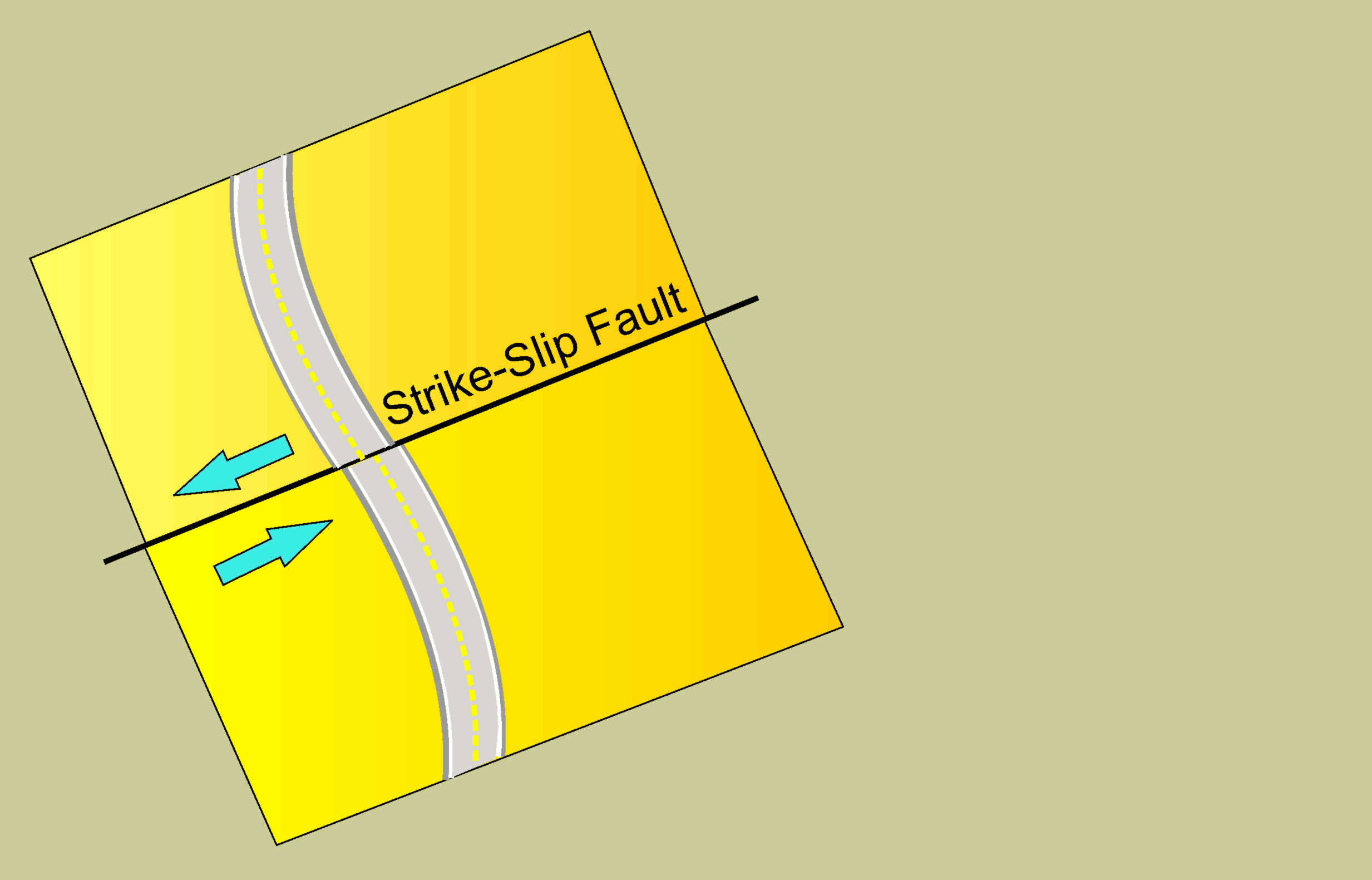
Strike Slip Fault
If the movement of a fault is predominately horizontal, the fault is considered a strike-slip fault. The San Andreas Fault zone is one of the most famous examples of a strike-slip fault in the United States.
Dip Slip Faults
If the movement along a fault is predominately vertical, the fault is considered to be a dip-slip fault, or in other words the displacement occurs along the dip plane of the fault. There are two main types of dip-slip faults; Normal faults and Reverse. In order to determine the differences between dip-slip faults it's important to understand the terms hanging wall and footwall.

Normal faults occur when the foot wall is displaced upward with respect to the hanging wall.
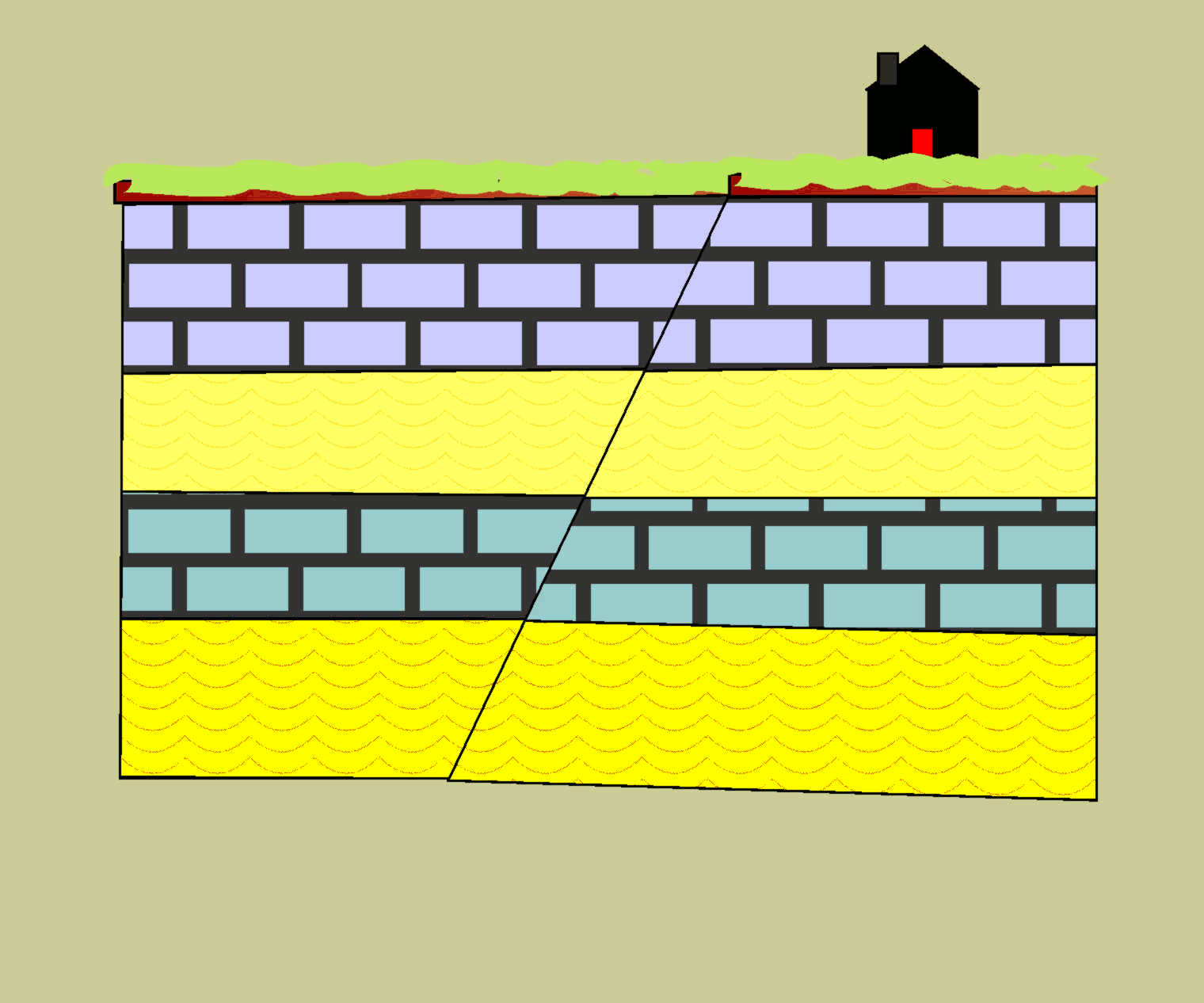
Reverse faults occur when the hanging wall is displaced upward with respect to the footwall.
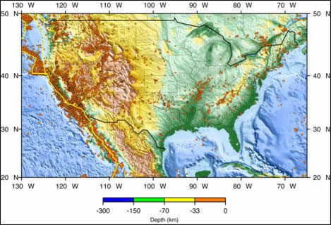
Where Do Earthquakes Occur?
Most earthquakes occur at plate boundaries. Earthquakes associated with faults on plate boundaries are called interplate earthquakes. About 5% of earthquakes are intraplate earthquakes and occur in the center of a tectonic plate.
Magnitude Scale
There are two scales in common use that give some measure of the size of an earthquake. These scales are quite commonly confused but measure very different parameters of the seismic event. The first scale, and the one most commonly heard on the news, is a magnitude scale. The magnitude scale was first developed in the 1930’s and is an objective instrumental measurement. It is based on the amplitude and amount of displacement of an instrument record trace calibrated and corrected with known distance, magnification and instrument factors. The magnitude scale is a logarithmic scale, meaning that each unit of increase (1, 2, 3…) of the scale value indicates a ten-fold increase in the value being measured.
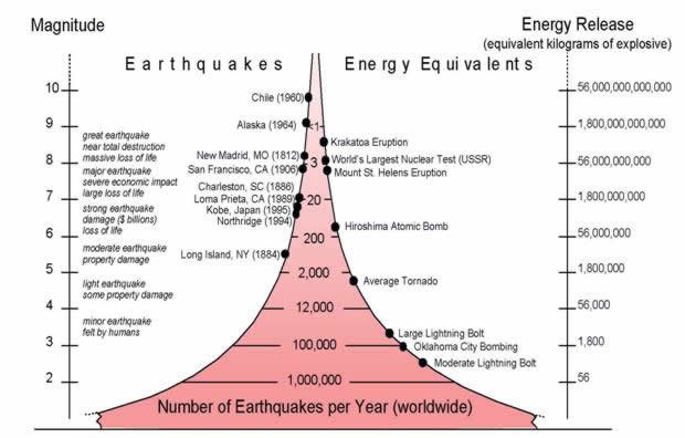
Therefore, if a magnitude 3 earthquake shows a record trace displacement of 1mm, then a magnitude 4 earthquake will show a trace displacement of 10mm. Each increase in magnitude corresponds with about 33 times more released energy. For example a magnitude 1 earthquake is equal to 56 kilograms of explosive energy. A magnitude 2 earthquake is then equal to 1,800 kilograms of explosive energy (approximately 56 times 33). A magnitude 7 earthquake releases 56,000,000,000 kilograms of explosive energy compared to a magnitude 8 earthquake which releases 33 times more energy. That’s approximately 1,800,000,000,000 kilograms of energy! As one can see, the amount of energy released in an earthquake drastically increases the higher the magnitude of the earthquake.
Intensity Scale
The other scale often used to indicate earthquake size is the Modified Mercalli Intensity scale. Intensity is a qualitative measure of the strength of ground shaking at a particular site. It is a subjective scale relying on the observations of people trained to relate the earthquake effects to a numeric scale from I-X+ (Roman numerals are used to distinguish this as an empirical scale). Because this is an observational scale, the intensity will decrease as a function of the distance from the epicenter. Most people (but not all) in an area experiencing Intensity III effects will just feel the earthquake shock. Intensity VII areas are indicated when damage is slight to moderate. Some people may have found it difficult to stand during the quake; chimneys, windows and plaster walls will be cracked; furniture may have overturned. Although damage may be moderate in an area of Intensity VII, it will be mostly architectural damage—i.e. it will look bad but almost all damage will be superficial. Beyond Intensity VII we start seeing structural damage and some collapse buildings. At first only poorly designed structures are destroyed, but as the Intensity level reaches X damage increases significantly.
The Modified Mercalli Intensity Scale
| MMI Value | Perceived Shaking | Potential Damage | Full Description |
|---|---|---|---|
| I. | Not Felt | None | Not Felt |
| II. | Weak | None | Felt by persons at rest, on upper floors, or favorably placed. |
| III. | Weak | None | Felt indoors. Hanging objects swing. Vibration like passing of light trucks. May not be recognized as an earthquake. |
| IV. | Light | None | Hanging objects swing. Vibration like passing of heavy trucks; or sensations of a jolt like a heavy ball striking the walls. Standing motor cars rock. Windows, dishes, doors rattle. Glasses clink. Crockery clashes. In the upper range of IV, wooden walls and frame creak. |
| V. | Moderate | Very Light | Felt outdoors; direction estimated. Sleepers wakened. Liquids disturbed, some spilled. Small unstable objects displaced or upset. Doors swing, close, open. Shutters, pictures move. Pendulum clocks stop, start, change rate. |
| VI. | Srong | Light | Felt by all. Many frightened and run outdoors. Persons walk unsteadily. Windows, dishes, glassware broken. Knickknacks, books, etc., off shelves. Pictures off walls. Furniture moved or overturned. Weak plaster and masonry cracked. Trees, bushes shaken (visibly, or heard to rustle). |
| VII. | Very Strong | Moderate | Difficult to stand. Noticed by drivers of motors cars. Furniture broken. Damage to masonry, including cracks. Weak chimneys broken at roof line. Fall of plaster, loose bricks, stones, tiles, cornices (also unbraced parapets and architectural ornaments). Waves on pond water, turned with mud. Small slides and caving in along sand or gravel banks. Large bells ring. Concrete irrigation ditches damaged. |
| VIII. | Severe | Moderate/Heavy | Steering of motor cars affected. Damage to masonry. Twisting, fall of chimneys, factory stacks, monuments, towers, elevated tanks. Frame houses moved on foundations if not bolted down. Branches broken from trees. Changes in flow or temperature of springs and wells. Cracks in wet ground and on steep slopes. |
| IX. | Violent | Violent/Heavy | Some Masonry destroyed, heavily damaged or completely collapsed. General damage to foundations. Frame structures, if not bolted, shifted off foundations. Frames racked. Serious damage to reservoirs. Underground pipes broken. Conspicuous cracks in ground. In alluvial areas sand and mud ejected, earthquake fountains, sand craters. |
| X. | Extreme | Very Heavy | Most masonry and frame structures destroyed with their foundations. Some well-built wooden structures and bridges destroyed. Serious damage to dams, dikes, embankments. Large landslides. Water thrown on banks of canals, rivers, lakes, etc. Sand and mud shifted horizontally on beaches and flat land. Rails bent slightly. |
In general earthquakes smaller than magnitude 2.5 will not be felt in most situations, they are simply too small and will certainly do no damage. Earthquakes between magnitude 2.5 and 5 will be increasingly felt but generally do little damage. When earthquakes scale to over magnitude 5 their effects become highly significant. Earthquakes of magnitude 5 to 6 will almost always cause some damage, but most of it will be architectural rather than structural. An earthquake of magnitude 6 can cause significant architectural damage and some structural damage and collapse of poorly-built structures. The area of damage will tend to be roughly bulls-eye shaped, with the greatest damage in the immediate epicentral area and lessening damage radially away from that area. This general pattern will be distorted more or less by variations in the nature of the bedrock and topography of the region in relation to the source of the earthquake and the exact manner in which it releases its energy. An earthquake of magnitude 7 will cause near total devastation in the epicentral area and cause structural damage and collapse of poorly-built structures over a much larger area (remember, this earthquake is 30 times more powerful than a magnitude 6 event). The great earthquakes, those over magnitude 8, will destroy most of the infrastructure in a very large area, several 10s of miles in diameter, and can cause structural damage and collapse of poorly-built structures as much as 100 miles away. Great earthquakes can still be felt many hundreds of miles away.
Seismic Waves
Two main types of seismic waves are generated in an earthquake.
Body waves are seismic waves that travel through the interior, or the body, of the earth. There are two main types of body waves; primary waves and secondary waves. Primary waves, or P waves, are compressional waves and travel faster than Secondary, or S waves. As a result, P waves are first to be detected by a seismic station after an earthquake has occurred, thus “primary”. Secondary waves, or S waves, travel in a side-to-side motion and move through the rock perpendicular to the direction the wave is traveling. S waves travel slower than P waves are recorded by seismic stations after the P wave arrival.
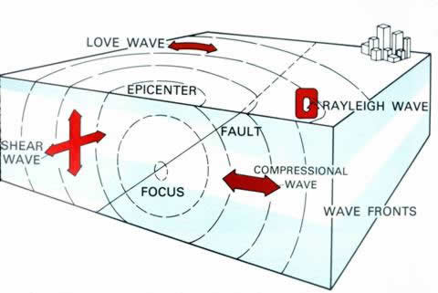
Illustration courtesy of the USGS
Surface waves travel through the very outer layers of the earth’s crust and arrive at a seismic station after the P and S waves. Two main types of surfaces waves are Raleigh and Love waves. Raleigh waves travel in a circular or rolling motion through the earth’s crust, similar to that of an ocean wave on the water. Love Waves are a type of surface wave that travels in a horizontal, side-to-side motion through the outer layer of the earth’s crust.
Determining An Earthquake Epicenter
The amount of time that passes between the arrival of the Primary wave and the Secondary wave allows seismologists to determine the distance from the seismic station to the earthquake epicenter. When a seismic station records a P wave arrival, the longer it takes for the S wave to arrive, the farther away the earthquake epicenter.
Historic Earthquakes
New Madrid Seismic Zone
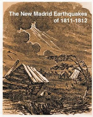
On December 16, 1811 residents living in the region near New Madrid, Missouri were jolted awake at 2:15 AM by a major earthquake. Cabins collapsed, people were frightened, and the land surface was severely changed by liquefaction. The shaking was felt as far away as New England and Canada. Scientists estimate that this event measured over a M7.0 (Johnston and Schweig, 1996). This marked the first of a series of powerful earthquakes that spanned a three-month period. Hundreds of aftershocks were reported for over a year.
Since that time, at least 20 damaging earthquakes have occurred in the NMSZ (Nuttli, 1982). An estimated M6.0 earthquake was reported near the town of Marked Tree, Arkansas on January 4, 1843. This earthquake caused the land to subside forming new lakes and did damage to chimneys and brick structures (Jackson, 1979). A M5.0 earthquake was recorded on March 24, 1976 in Poinsett County. This earthquake was felt over an area of 174, 000 sq. miles (280,000 sq. kilometers) bounded by Centralia, Illinois; Hopkinsville, Kentucky; Nashville and Clifton, Tennessee; Birmingham, Alabama; Little Rock, Arkansas; and Jefferson City, Missouri. In Arkansas, multiple cities reported an Intensity VI. Power outages, downed telephone lines in Jonesboro, broken windows in Paragould, cracked plaster in Marked Tree, roof damage and fallen ceiling tile as far away as Decatur, Arkansas (Jackson, 1979).
The most recent events to rattle the residents of northeast Arkansas were felt near the towns of Caraway and Manila, Arkansas in Poinsett County in 2005. Both of these earthquakes registered a M4.1 with an Intensity V. Although significant damage has not been reported in recent years, the NMSZ is still considered active and is potentially capable of generating powerful earthquakes.
The following is an excerpt from “The New Madrid Earthquake” by Myron Fuller:
“The evening of December 15, 1811, the New Madrid area was clear and quiet, with no unusual conditions which could be regarded as portending the catastrophe soon to take place. A little after 2 o’clock in the morning of December 16, the inhabitants of the region were suddenly awakened by the groaning, creaking, and cracking of the timbers of the houses and cabins in which they were sleeping, by the rattle of furniture thrown down, and by the crash of falling chimneys. In fear and trembling they hurriedly groped their way from their houses to escape the falling debris, and remained shivering in the winter air until morning, the repeated shocks at intervals during the night keeping them from returning to their weakened of tottering dwellings. Daylight brought little improvement to their situation, for early in the morning another shock, preceded by a low rumbling and fully as severe as the first, was experienced. The ground rose and fell as earth waves, like a long, low swell of the sea, passes across its surface, tilting the trees until their branches interlocked and opened the soil in deep cracks as the surface was bent. Landslides swept down the steeper bluffs and hillsides: considerable areas were uplifted, and still larger areas sunk and became covered with water emerging from below through fissures or little “craterlets” or accumulating from the obstruction of the surface drainage. On the Mississippi great waves were created, which overwhelmed many boats and washed others high on the shore, the return current breaking off thousands of trees and carrying them out into the river. High banks caved and were precipitated into the river, sand bars and points of islands gave way, and whole islands disappeared."
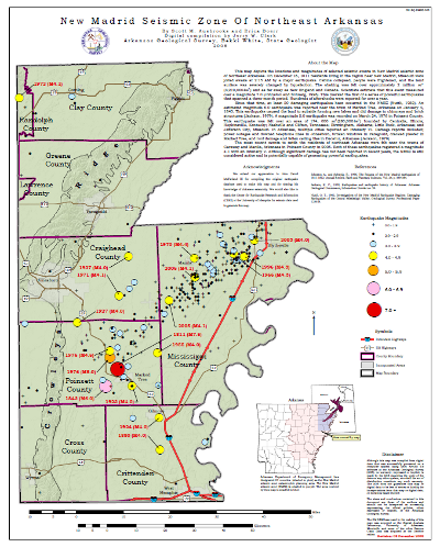
This map depicts the locations and magnitudes of selected seismic events in New Madrid seismic zone of Northeast Arkansas. On December 16, 1811 residents living in the region near New Madrid, Missouri were jolted awake at 2:15 AM by a major earthquake. The shaking was felt as far away as New England and Canada. Scientists estimate that this event measured over a M7.0 (Johnston and Schweig, 1996). This marked the first of a series of powerful earthquakes that spanned a three-month period. Hundreds of aftershocks were reported for over a year.
Since that time, at least 20 damaging earthquakes have occurred in the NMSZ (Nuttli, 1982). An estimated M6.0 earthquake was reported near the town of Marked Tree, Arkansas on January 4, 1843. This earthquake caused the land to subside forming new lakes and did damage to chimneys and brick structures (Jackson, 1979). A M5.0 earthquake was recorded on March 24, 1976 in Poinsett County. This earthquake was felt over an area of 174, 000 sq. miles (280,000 sq. kilometers) bounded by Centralia, Illinois; Hopkinsville, Kentucky; Nashville and Clifton, Tennessee; Birmingham, Alabama; Little Rock, Arkansas; and Jefferson City, Missouri. In Arkansas, multiple cities reported an Intensity VI. Power outages, downed telephone lines in Jonesboro, broken windows in Paragould, cracked plaster in Marked Tree, roof damage and fallen ceiling tile occurred as far away as Decatur, Arkansas (Jackson, 1979).
Other recent events in northeast Arkansas were felt near the towns of Caraway and Manila, Arkansas in Poinsett County in 2005. Both earthquakes registered a M4.1 with an Intensity V. Although significant damage has not been reported in recent years, the NMSZ is still considered active and is potentially capable of generating powerful earthquakes.
The Enola Swarm Area
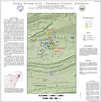
The Enola swarm was initiated by a magnitude 1.2 earthquake recorded on January 12, 1982 near the town of Enola in Faulkner County, Arkansas. Since then, over 40,000 seismic events have been recorded in the Enola area. Most of the recorded seismic events are microquakes, but at least 93 earthquakes have been felt in the local area by at least one person during the first year of seismic activity. Earthquake magnitudes have not exceeded a 4.5, which occurred on Jan. 21, 1982. No structural damage has ever occurred, although there have been reports of broken china.
This map represents only a small sampling of seismic events that have occurred in the Enola swarm area since 1982. Events that are more recent include a magnitude 4.4 on May 4, 2001 followed by aftershocks greater than magnitude 2.0 over several days. Approximately 2,500 seismic events were recorded in 2001 on a portable seismic network. The most recent seismic event was a magnitude 2.8 on October 17, 2006.
These earthquakes are not associated with the New Madrid seismic zone of northeast Arkansas and there is no history or research that suggests any cause/effect relationship between the two regions.
Explore Historic Earthquakes Web Map
References
- Chiu, J., Johnston, A.C., Metzeger, A.G., Haar, L. and Fletcher, J., 1984, Analysis of analog and digital records of the 1982 Arkansas earthquake swarm: Bull. Seismol. Soc. Am., 74: 1721-1742.
- Jackson, K. C., 1979, Earthquakes and earthquake history of Arkansas: Arkansas Geological Commission, Information Circular no. 26.
- Johnston, A., et al, 1982, The Central Arkansas earthquake swarm: Tennessee Earthquake Information Center (TEIC) Special Report # 8, parts 1, 2.
- Johnston A., and Schweig, E., 1996, The Enigma of the New Madrid earthquakes of 1811-1812: Annual Review, Earth and Planetary Sciences, Vol. 24, p. 339-384.
- McFarland, J. D., 2001, Faulkner County Earthquakes: Arkansas Geological Commission, Open-File Report.
- Nuttli, O. T., 1982, Investigations of the New Madrid Earthquake Regions: Damaging Earthquakes of the Central Mississippi Valley, Geological Survey, Professional Paper 1236-B.
Case Studies
Scheduling A Guest Speaker
The Arkansas Geological Survey is committed to educating the public about earthquake issues in Arkansas. We have presented Earthquake: 101 lectures to school classes, emergency management, and many community organizations. Please contact the Arkansas Geological Survey if you are interested in scheduling a guest speaker.
Earthquake Activities
Slinky Demonstrations
IRIS Instructional Resources
FEMA for kids
USGS for Kids
Classroom Activities
Arkansas Earthquake Geocache
Earthquake Preparedness
February is Earthquake Awareness Month

World's Largest Earthquake Drill
Tips from Arkansas Department of Emergency Management
Personal Emergency Kit
Home Survival Kit
Seven Steps to Earthquake Safety
Earthquake Response
During an Earthquake
After an Earthquake
Drop, Cover, and Hold on
Report an Earthquake
Report an Earthquake to United States Geological Survey:
Recent Earthquakes from CERI at the University of Memphis