County Seismicity Maps
| AGC/AGS Series | Digital Geohazard Maps |
| Number Series | GH-EQ-CO |
| Title | Scott M. Ausbrooks, David H. Johnston, William L. Prior, and Erica Doerr |
| Author (s) | S.M. Ausbrooks and Erica Doerr |
| Date | Various |
| Scale | |
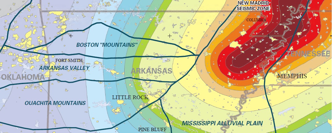
| General Description |
This map was generated from a selection of seismic events that have occurred from 1699 to the present in Arkansas. The seismic data have been taken from publications of the Center for Earthquake Research and Information (CERI) at the University of Memphis, the Department of Earth and Atmospheric Sciences at Saint Louis University, the U. S. Geological Survey, the Arkansas Geological Survey, the Eastern Section of the Seismological Society of America and the University of Arkansas at Little Rock. We extend our appreciation to John David McFarland III for compiling the original earthquake database used to make this map and for sharing his knowledge of Arkansas Seismicity. We would also like to thank the Center for Earthquake Research and Information (CERI) at the University of Memphis for seismic data used to generate these maps. |
| Availability | Yes. Paper copy or free download. |
| Price | Paper map cost $3.50 per sq. foot or download for free. |
| Shipping and handling | Contact Sales Office at (501) 296-1877, for shipping and handling charges. |
County Seismicity Maps
Arkansas county seismicity map ![]() (2.03 MB)
(2.03 MB)
Ashley county seismicity map ![]() (21.2 MB)
(21.2 MB)
Baxter county seismicity map ![]() (1.78 MB)
(1.78 MB)
Benton county seismicity map ![]() (25.7 MB)
(25.7 MB)
Boone county seismicity map ![]() (19.3 MB)
(19.3 MB)
Bradley county seismicity map ![]() (11.9 MB)
(11.9 MB)
Calhoun county seismicity map ![]() (11.9 MB)
(11.9 MB)
Carroll county seismicity map ![]() (2.33 MB)
(2.33 MB)
Chicot county seismicity map ![]() (10.4 MB)
(10.4 MB)
Clark county seismicity map ![]() (2.38 MB)
(2.38 MB)
Clay county seismicity map ![]() (1.37 MB)
(1.37 MB)
Cleburne county seismicity map ![]() (1.64 MB)
(1.64 MB)
Conway county seismicity map ![]() (1.83 MB)
(1.83 MB)
Craighead county seismicity map ![]() (1.37 MB)
(1.37 MB)
Crittenden county seismicity map ![]() (1.19 MB)
(1.19 MB)
Cross county seismicity map ![]() (1.44 MB)
(1.44 MB)
Faulkner county seismicity map ![]() (2.53 MB)
(2.53 MB)
Fulton county seismicity map ![]() (2.34 MB)
(2.34 MB)
Greene county seismicity map ![]() (1.39 MB)
(1.39 MB)
Independence county seismicity map ![]() (2.20 MB)
(2.20 MB)
Izard county seismicity map ![]() (1.77 MB)
(1.77 MB)
Jackson county seismicity map ![]() (1.47 MB)
(1.47 MB)
Lawrence county seismicity map ![]() (1.78 MB)
(1.78 MB)
Lee county seismicity map ![]() (1.35 MB)
(1.35 MB)
Marion county seismicity map ![]() (1.92 MB)
(1.92 MB)
Mississippi county seismicity map ![]() (2.28 MB)
(2.28 MB)
Monroe county seismicity map ![]() (1.58 MB)
(1.58 MB)
Montgomery county seismicity map ![]() (3.12 MB)
(3.12 MB)
Newton county seismicity map ![]() (4.30 MB)
(4.30 MB)
Phillips county seismicity map ![]() (2.07 MB)
(2.07 MB)
Poinsett county seismicity map ![]() (1.86 MB)
(1.86 MB)
Pope county seismicity map ![]() (2.40 MB)
(2.40 MB)
Prairie county seismicity map ![]() (1.48 MB)
(1.48 MB)
Randolph county seismicity map ![]() (1.72 MB)
(1.72 MB)
Searcy county seismicity map ![]() (1.93 MB)
(1.93 MB)
Sharp county seismicity map ![]() (2.12 MB)
(2.12 MB)
StFrancis county seismicity map ![]() (1.53 MB)
(1.53 MB)
Stone county seismicity map ![]() (1.95 MB)
(1.95 MB)
VanBuren county seismicity map ![]() (2.22 MB)
(2.22 MB)
Washington county seismicity map ![]() (5.99 MB)
(5.99 MB)
White county seismicity map ![]() (2.63 MB)
(2.63 MB)
Woodruff county seismicity map ![]() (1.42 MB)
(1.42 MB)